If we’re going to talk about Brockton’s history, we should start with a simple question: where is Brockton?
Seems straightforward, but Brockton’s shape, size, and identity have changed considerably over time. To understand its evolution, let’s take a look at how maps have defined Brockton over the past 175 years.
175 Years of Change (1850 – 2025)
A scan of historical maps shows that Brockton’s boundaries have constantly shifted. The gallery below traces these changes, mapping Brockton’s transformation from 1850 to today.
Gallery of Brockton’s Shifting Boundaries, 1850 – 2025 (swipe ⬅️)
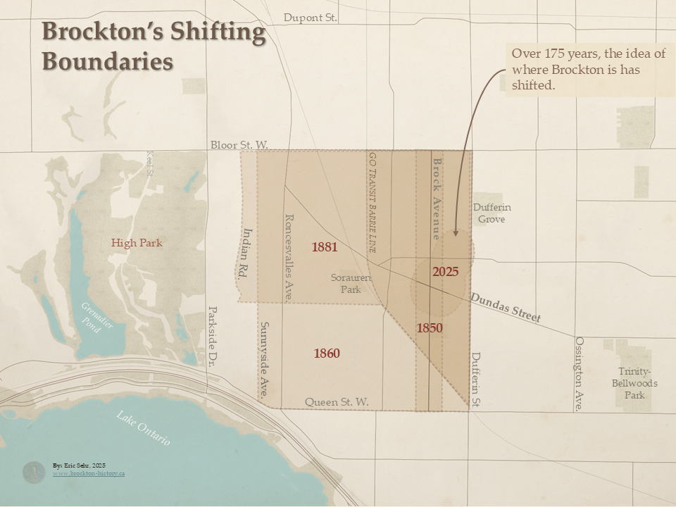
We’ll take a look at the maps that established these boundaries.1
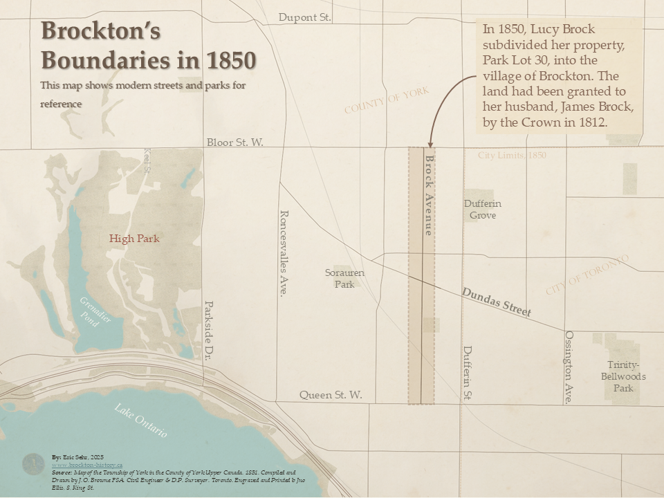
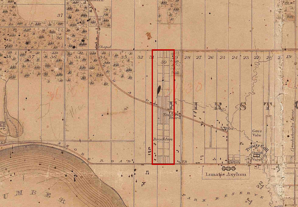
Brockton in 1851: Park Lot 30
For the first 40 years, Brockton’s boundaries were determined by surveyors, landowners, and, eventually, an act of incorporation.
The name Brockton first appeared in 1850 on a plan of subdivision for land owned by Lucy Brock. Soon after, real estate ads in The Globe promoted Brockton as a village, and Browne’s Map of the Township of York was the first to show it cartographically.
Browne, who was using Plans filed in the Registry Office for the County of York County, was making a map funded by people wanting to sell real estate in and around Toronto. By boldly marking her estate BROCKTON, Lucy’s agents found a way to have her estate outside of Toronto standout.
At this point Brockton was limited to Park Lot 30, a narrow strip of land just 1,000-feet (300 metre) wide, stretching between Queen Street and Bloor Street.
The map shows no buildings in the planned village itself. The structures visible along Dundas Street were actually in Park Lot 29 to the east and Park Lot 31 to the west – outside of the footprint drawn by Browne.
Despite being called a “village,” Brockton wasn’t officially recognized municipality. It remained part of York County, which then covered all of modern York Region and the City of Toronto.
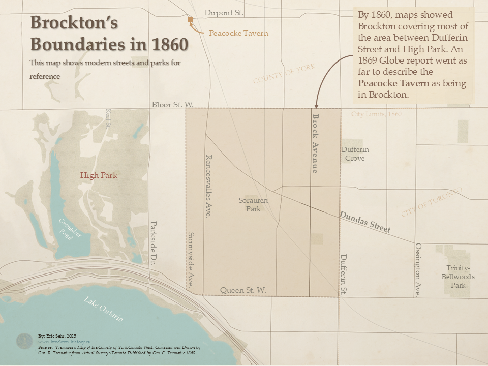
Brockton in 1860: Expanding West
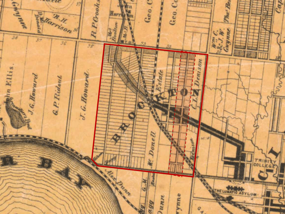
By 1860, the name Brockton had expanded beyond its original subdivision. Tremaine’s Map of the County of York shows it extending east to Dufferin Street and west to Sunnyside Avenue.
An 1869 Globe article even described the Peacocke Tavern – located much farther north-west near Dundas Street and Annette Street – as part of Brockton. This suggests that people in the Toronto, saw Brockton less a specific subdivision, and more of a general name for the places outside the city along Dundas Street.
The 1860 Tremaine map of York County was produced as part of a massive series of 18 “wall atlases, between 1856 and 1864. The business let landowners put their name on the map. Those willing to pay could even have their homes or business illustrated on the margins.2
By this time, much Brockton had been subdivided. The map shows two major landowners, the McDonell Estate and CL Denison. Tremaine’s map also shows Dundas Street as “built-up” from Ossington to Lansdowne. We’ll get into more details about land ownership in this period in future article.
In just 10 years, Brockton’s geographic identity grew significantly, reaching it’s broadest extent, solidifying its place as distinct place west of Toronto.
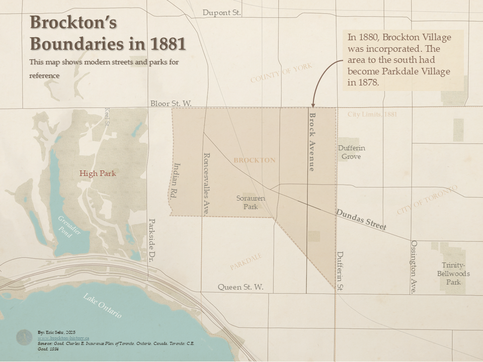
Brockton Village (1880-1884): Official Incorporation
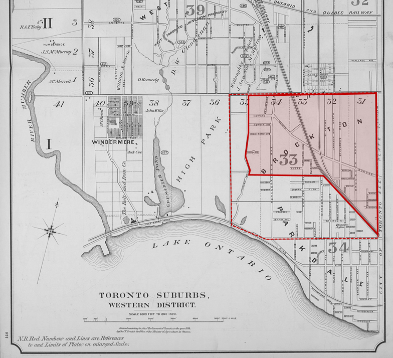
Brockton officially became a village in 1880 when it was incorporated by an Act of Incorporation. The municipal government was organized in 1881, which is why many records, including the corporate seal, refer to 1881 as its founding date.
At this point Brockton’s boundaries extended from Indian Road to Dufferin Street and from the railway corridor up to Bloor Street West. This is a smaller area than from the 1860s, because land to the south became the Village of Parkdale in 1878. Parkdale was the product of another more sophisticated and successful real estate venture, than Lucy Brock’s 28 years earlier.
Brockton emerged as a village at a time when there was an increasing need and sophistication for detailed maps of rapidly growing cities. Charles Edward Goad started a company that made maps for insurance underwriters, the real estate industry, and private fire brigades.3
Today these maps one of the best sources resources for understanding how Toronto and Brockton looked in the late 19th and early 20th centuries.
By 1884, Brockton’s short-lived independence ended – it was annexed by the City of Toronto, and it’s identity began to fade into of civic memory.
Brockton Today
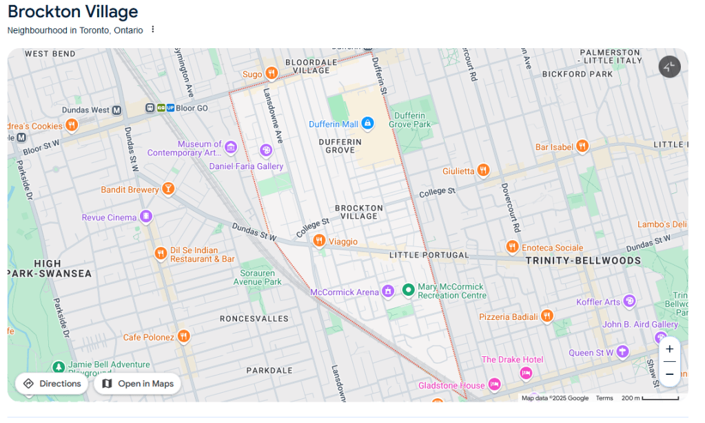
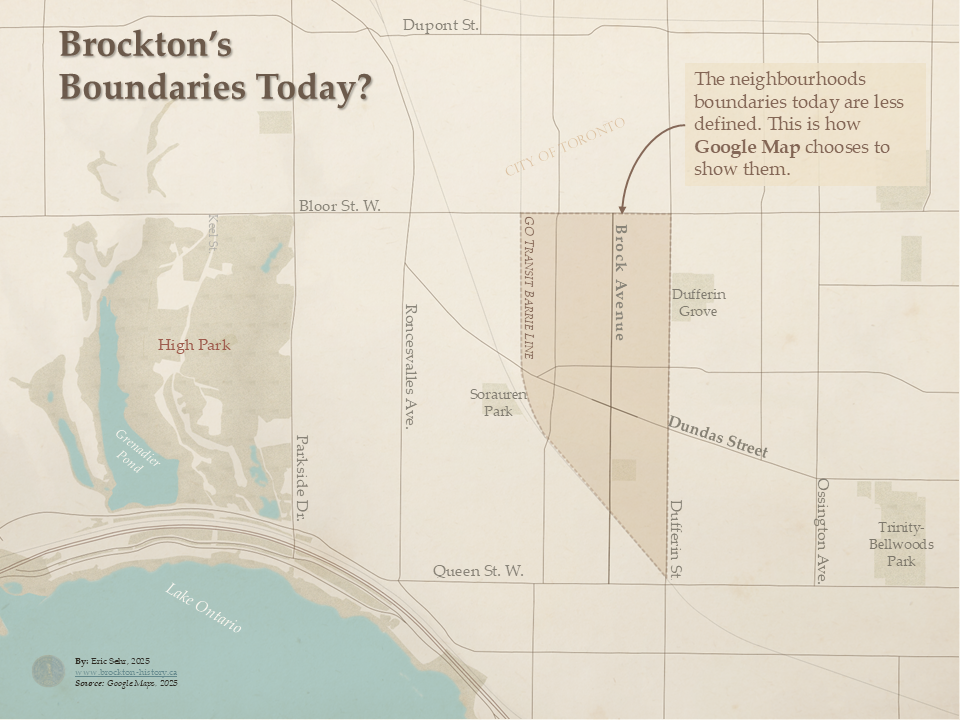
If 19th-century Toronto had Browne, Tremaine, and Goads, today we have Brothers Lars and Jens Rasmussen, who co-founded the company that would become Google Maps. So what does Google have to say about Brockton?
A quick search shows a triangle south of Bloor Street West, between the rail corridor and Dufferin Street. Similar to 1884 village boundaries, but missing Roncesvalles and the Junction Triangle’s Sterling Road pocket.
Yet, many people living in this area may not identify as Brockton residents at all. Instead they might prefer Bloordale, Dufferin Grove, or Little Portugal. Google Maps acknowledges this by showing overlapping neighbourhood names – a reminder neighbourhood borders are messy.
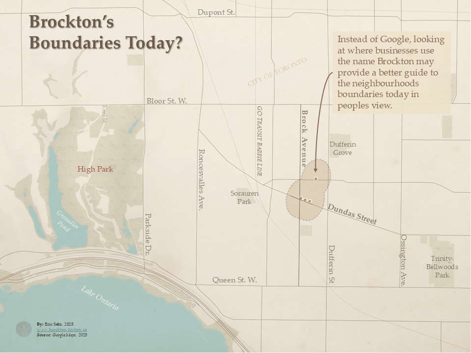
Another way to define Brockton is by looking at local businesses that use the name. Most still cluster around the historic village core near Brock Avenue and Dundas Street West.
Shifting Boundaries, Varied Georgraphies
So, where is Brockton? It depends.
As we’ve seen, Brockton’s boundaries have continuously shifted over time. Different historical topics will focus on different time periods, and the geographic focus will depend on how the village or neighbourhoor was defined. For this project, I’ll generally default with Google’s present-day definition, but earlier maps—like Tremaine’s from 1860—reveal that Brockton had a much larger footprint. Some topics may even require zooming to explore the broader history of York County and western Toronto.
How do you define Brockton? Does Google get it right? Let me know what you think!
Sources
- Old Toronto Maps. Accessed February 20, 2025. https://oldtorontomaps.blogspot.com/. ↩︎
- Segger, Graham. “Tremaine’s Map: Establishment.” Graham Segger, accessed February 20, 2025. https://grahamsegger.com/tremaines-map-establishment/. ↩︎
- Ng, Nathan. “Goad’s Atlas of Toronto Online.” Recursion’s Adventures from a Fractal Life, April 2012. Accessed February 20, 2025. https://skritch.blogspot.com/2012/04/goads-atlas-of-toronto-online.html. ↩︎

Leave a comment