Before I get started, I want to thank everyone who has followed along Brockton: A Lost Toronto Village in 2025. Since my last two posts on Dundas, I’ve pivoted to researching the early estates in Toronto’s west end. This means I’ve been digging deep into the Ontario Land Registry’s Historical Books, with the goal of building a decent map of landownership in the west end by 1840, similar to what I did for Brockton’s earliest landowners.
The Historical Books are a great public asset. But they’re not for the faint of heart, and I’m still learning how to navigate them. The Etobicoke Historical Society has a helpful guide on how to access and interpret these records.
My approach right now is to scan the Park Lots between Bathurst Street and the Humber River between the lake and St. Clair Ave. W. and build a database of landownership from the 1790s to the 1840s. Below I’ll show my approach to collecting the data starting with Park Lot 29 (which is defined by Dufferin Street to Shirley Street).
Building my Land Ownership Database
Fist off, I need to figure out what information I’ll be capturing. The information I’ve decided I need to build my map from the books are:
- BookNo – the land registry book number
- BookPage – the book page number
- ViewerPage – the online page number
- Link – link to the record
- GeoUnit – the unique identifier I’ve given the parcel (e.g., Park Lot 29 = PL029)
- ScopeLabel – the heading on the historical book page
- Plan No – the subdivision plan number, if applicable
- ScopeType – whether its the whole lot or a part of the lot
- GeomtryStatus – have I digitized the lot
- Confidence_Scope -how confident am I in the geography (the records can be a bit tough to interpret, some early subdivisions were not numbered or I haven’t found a good map).1
- InsturmentNo – each transaction is assigned a number by the registry office
- InstDate – date the transaction took place
- RegDate – date the transaction was registered at the registry
- Grantor – who sold the land
- Grantee – who purchased the land
- Nature – the type of transaction
- Consideration – how much it cost
- Remarks – any comments that might have been written down
- EventType –
- AffectsOwnership – did ownership change, (yes/no)
- AffectsGeometry – did the plot change (i.e. was it subdivided), (yes/no)
- Owner_AsOf-1840 – the grantee was the owner in 1840.
- Note – any notes I made.
It’s a fair amount of detail, but I’m expecting that the 1798–1840 period has only four or five transactions for each park or township lot, which should keep the data I need to collect manageable. So let’s walk through an example of how I use ONLand’s Historical Books for Park Lot 29.
Using ONLand
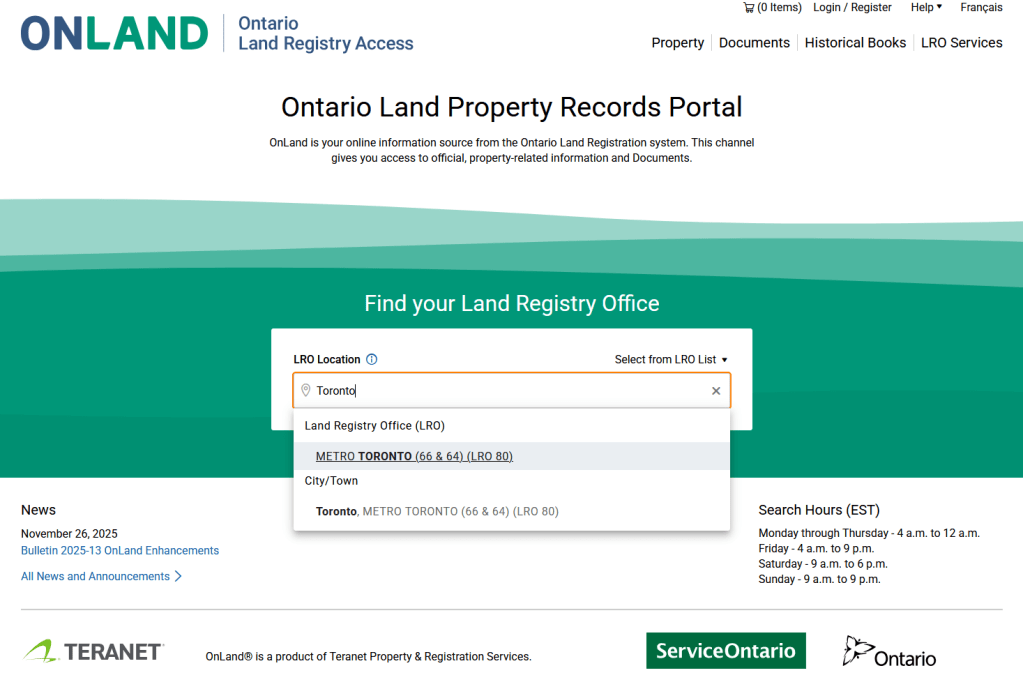
Step 1 – Find the right registry office. In our case it is Metro Toronto
Go to ONLand and look up your local registry office. In our case, it’s Metro Toronto.
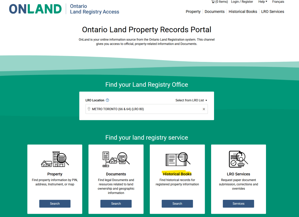
Step 2 – Open the Historical book search.
Select Search Historical Books once you’ve selected your land registry office.
Step 3 – Find your book.
This is the tricky part. To find a book, you need the legal description of the property. Because I’m searching for Park Lot 29, under “Property Description” I can search “Concession 1” and “Parklot 29.” But when I pull up Book #139B, the records are from the 1950s, not the early 19th century.

Even though I didn’t find the book I wanted, I did get an important clue – Park Lot 29 was tied to Book #139B.
Using that as a lead, I run a new search using “Search by Book Number” instead of Property Description. Searching 139 gives me eight results, including “Park Lot 27; Park Lot 28, Park Lot 29, Page 1 to 164.”
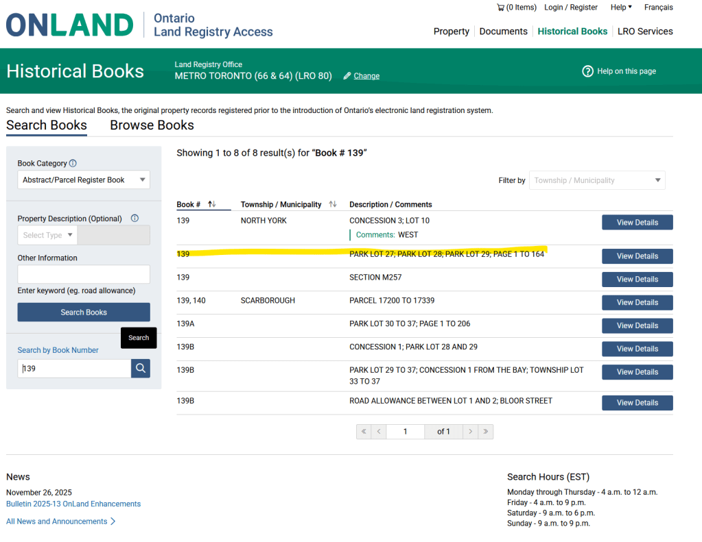
I know this is the book I want because, on the first page the earliest instrument date is 1798. That’s my signal that this volume includes the early records I’m looking for.
Step 4 – Data Entry
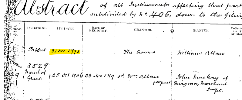
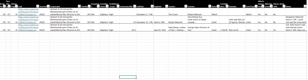
Now that I found the right book, I have to figure out what’s in it. It’s a bit of a jumble. But I find my first entry on Page 53 under the heading “Abstract of all Instruments affecting that part of Park Lot 29 subdivided by Plan 294 prior to the fyling of said Plan”
Under that heading, i have three entries—1798, 1796, and 1825—and they let me trace ownership for that part of Park Lot 29 (Plan 294). By 1840, it’s owned by George Taylor Denison.
Next Month – Data Entry and Mapping
Once I’m finished the data entry for the lots I’m interested in, I’ll be able to produce a map of landowners in the 1840s in Brockton Village, including any early subdivisions that show up in the records.
This process can be time-consuming, so I’ll provide updates along the way.
- For example, I would label the lot described on page 107, as low confidence until I I’m ready to map it: “Abstract of all Instruments affecting that part of Park Lot 29 bounded on the N by the S lines of Plan 964; on the S by N line of Plan 938; on the E by Part Lot 28; on the W by the E limit of Park Lot 30 being about 1700 feet of E limit of Park Lot 29… 107 ft. s. of Bloor St.” ↩︎

Leave a comment