It’s not every day that you stumble upon something truly exciting while browsing the archives. But on a cold January evening in 2022, that’s exactly what happened.
I had been researching the history of Brockton – a lost Toronto village – since moving here in 2016. At the time, I was preparing for a Jane’s walk focused on the history of the neighbourhood, looking for more information about the Denison family, one of the area’s most influential landowners.
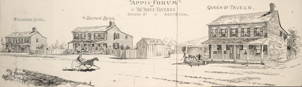
I was looking for diaries and court cases related to real estate deals. If there was one thing I felt I knew for certain, it was that no images existed of Brockton before the growing city consumed it in the 1880s. The sole exception was an 1893 sketch published in the Toronto Globe, where the artist did their best to depict Brockton has it had appeared four decades earlier.
Then, unexpectedly, I found something else.
Buried in the Denison family files at the Library and Archives Canada was a simple but intriguing entry: “View of Brockton, 1855.”
The item was described as “pencil on paper” by George Taylor Denison II, whose Rusholme estate once stood just east of Brockton. The Denisons’ were among Toronto’s wealthiest early settlers, their influence stretching back to the 1790s when George’s grandfather, John Denison, first arrived. But there was no preview of the image, just the title.
I had no idea what it looked like. Was it a rough sketch? A detailed drawing? A map? The only way to find out was to request a high-resolution copy from the archive. So I did.
And then, I waited.
For sixteen months.
To be honest, I forgot about it.
I received some other documents about the Denisons’ and assumed the record didn’t exist or had been lost. The anticipation faded, replaced by other research and new discoveries.
Then, out of nowhere, in May 2023, an email landed in my inbox. The image had arrived.
I opened the file, unsure of what to expect. And there it was. A forgotten sketch of Brockton as it appeared in 1855, captured by one of Toronto’s most prominent landowners and father to one of Toronto’s most notorious Confederate Civil War collaborators.
It’s a simple sketch that provides a never before seen glimpse of a lost village before it was absorbed into the city.
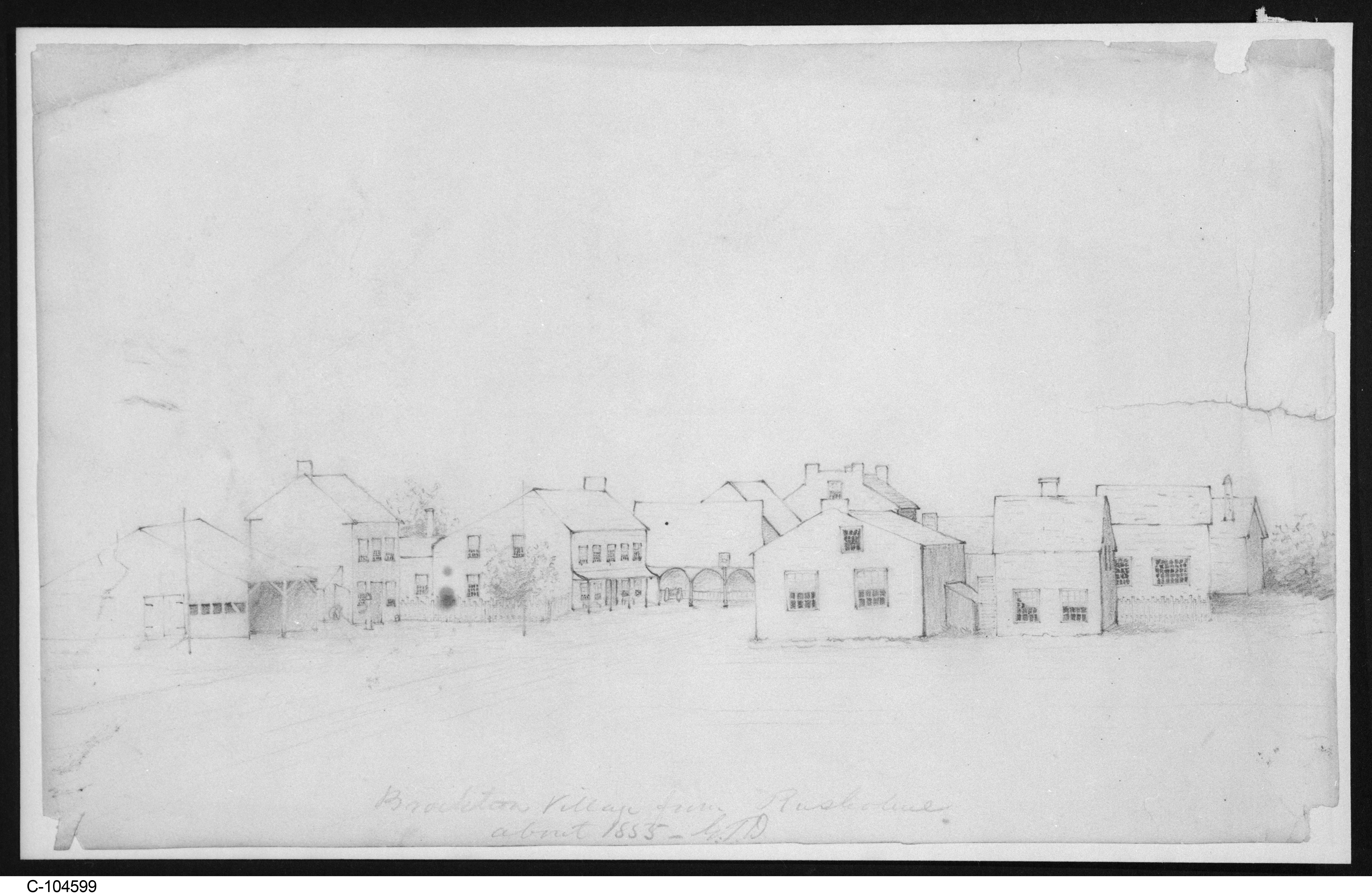
Denison, George T. 1853. View of Brockton, about 1853. Pencil on paper. Item ID 293654. Library and Archives Canada, accession no. 1955-015 PIC.
I imagined George in 1855, seated in his study, gazing westward from his estate. Perhaps he marveled at the small but growing village taking shape along Dundas Street, just beyond Toronto’s boundaries. Maybe he picked up a pencil and, with a few quick strokes, sought to capture this dusty little settlement that had sprung up on land his father had once owned and shaped for profit.
(Toronto Public Library)
Taking the Land to Make a Neighbourhood —how Brockton took shape.
But as I looked closer, something struck me: 1855 was only fifty years after Treaty 13. In another thirty years, this village would become a city neighbourhood.
I had been thinking a lot about how, in just half a century, this land had been completely transformed—partly because I was reading Mary P. Ryan’s Taking the Land to Make the City: A Bicoastal History of North America, which examines how urban expansion followed similar patterns across North America and inspired this websites tagline “Taking the land to making a neighbourhood —how Brockton took shape.”
From Baltimore to San Fransciso, land that was once Indigenous or rural was systematically transformed through surveying, speculation, and development. The book helped me see Brockton’s story in a new light—not just as a local curiosity, but as part of a larger history of how land was shaped to fit the needs of a growing city.
Brockton’s history is one of survey lines, shifting property boundaries, and global migrations. While traces of the village still linger in street layouts and a handful of surviving buildings, much of its past has been rewritten by waves of change. The forces of imperial land policy, settlement, speculation, and urbanization shaped this land in ways that are still visible today.
The plan for brockton-history.ca is dig deeper into this forgotten sketch, exploring the how the Brockton Village developed, who who lived here, and how a collection of estates slowly evolved into a village then very quickly into a city neighbourhood. Using primary sources, archival records, maps, census data, and city directories, we’ll reconstruct Brockton’s story and reveal how its past still echoes in the present.
By writing and sharing stories about Brockton and its evolution, I hope to connect my neighbours with the larger historical forces that shaped this neighbourhood, Toronto, and Canada itself and find the stories this forgotten sketch hold. Additionally, I hope to share some of the resources available to anyone interested in exploring their own streets and neighbourhood.
Let’s get started!

Leave a reply to ericvery Cancel reply