By 1815, the shape of west Toronto was already set. The British and Mississaugas of the Credit had negotiated treaties, while disagreeing on what they meant. Surveyors had laid out the land, two-thirds of it had been distributed to colonial officials, military officers, and British loyalist, and Dundas Street stretched west toward Burlington Bay. The one thing missing was people. Brockton Village wouldn’t emerge for another generation.
Historians have long argued that Upper Canada’s land policy was encouraged to concentrate land ownership, not spread it to create a landowning elite and a class of wage labourers, rather then a countryside filled with independent farmers. 1
A close look at who owned Toronto’s west end is a clear case study, and helps explain why the area was settled much more slowly than the stretch up Yonge Street into Markham.
1820 – Absentee landowners dominate
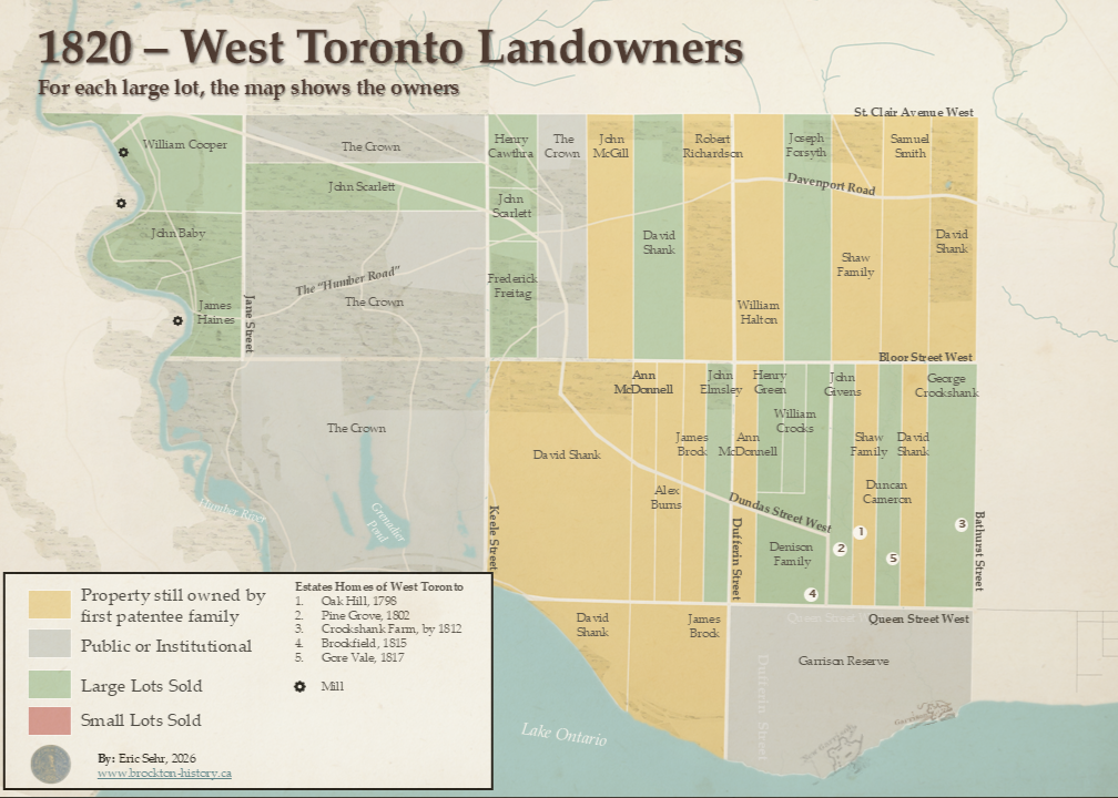
The official process of giving land away around the town of York (now Toronto) was rapid. By 1805, two-thirds of York Township, which West Toronto belonged, had already passed into private hands. Yet fewer than 500 people lived there, and only about 1,181 acres (under 5 percent of the granted land) were actually being farmed.
Fifteen years later the west end was still sleepy. Roughly three-quarters of land remained with the Crown, the original grantees, or their relatives. A few gentry estates had gone up near today Trinity Bellwoods Park, Oak Hill and Pine Grove before the War of 1812, Brookfield and Gore Vale after it. But it was still a largely forested landscape.
The one real settlement was along the Humber River, where William Cooper and his son Thomas had built grist and saw mills powered by the river, along with houses for millworkers and craftsman. Their two river bank communities (Milton Mills and Coopers Mill) would later grow into Lambton Village.2
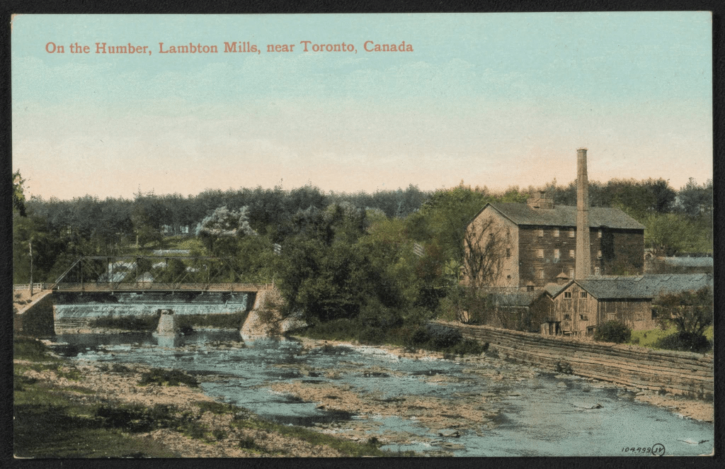
The Shank Holdings
Nearly a quarter of all privately held land in the area (about 4,900 acres) belonged to one man: David Shank. Shank rose through the military ranks during the Revolutionary War and was appointed Lieutenant Colonel of the Upper Canadian militia in 1798, about the same time he received most of his land in the west end. One contemporary noted, less than kindly, that Shank had risen from humble circumstances near Glasgow.3
In 1800 he married Cecilia Cooper, the daughter of a wealthy Scottish family with ties to the Tobacco Lords. When they died in Glasgow, David in 1830 and Cecilia in 1843, their combined estate totalled roughly £26,000, with Cecilia’s share nearly ten times his. Shank’s west end holdings were worth £2,400 -£3,600 in 1820. A real sum, but modest next to Cecilia’s fortune, a reminder of how hard it was to turn Upper Canada’s land abundance into actual wealth and a clue as to why it took awhile to sell the land after it was granted.
1830 – The local gentry expand
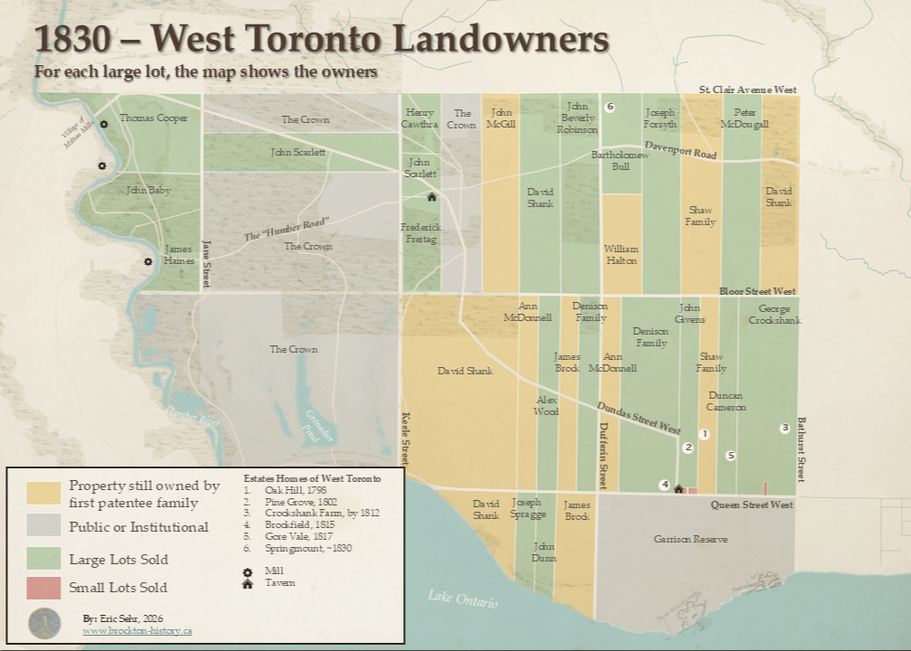
Through the 1820s, land moved slowly out of the hands of the first grantees, even as the roads west began to develop. With Shank and the Crown still sitting on significant holdings, only a couple of established families, George Crookshank and the Denisons, were adding to their existing estates.
There was an exception. Newcomer Bartholomew Bull, an Irish Methodist who arrived in 1818, was the first buyer without connections to the gentry or military. He purchased 100 acres along Davenport Road from William Halton and soon after built the first brick home outside the city, which he called Springmount.
Queen Street saw the area’s first real subdivision. Starting in 1823, John Givens began selling off his Queen street frontage in smaller lots to carpenters and independent farmers, and taverns sprang up to serve travellers to and from the Town of York along Dundas and Lake Shore roads. By 1824, James Farr, a friend and relative of brewer Joseph Bloor, was licensed to operate the Peacock Tavern on Dundas.4 In 1826, Julius Sandford opened a tavern near what’s now Ossington Avenue (then part of Dundas Street), on Queen Street on a corner lot he bought three years earlier.5 An 1834 map labelled the Ossington “Sandford’s Mail Road.”
1840 – A local gentry takes hold
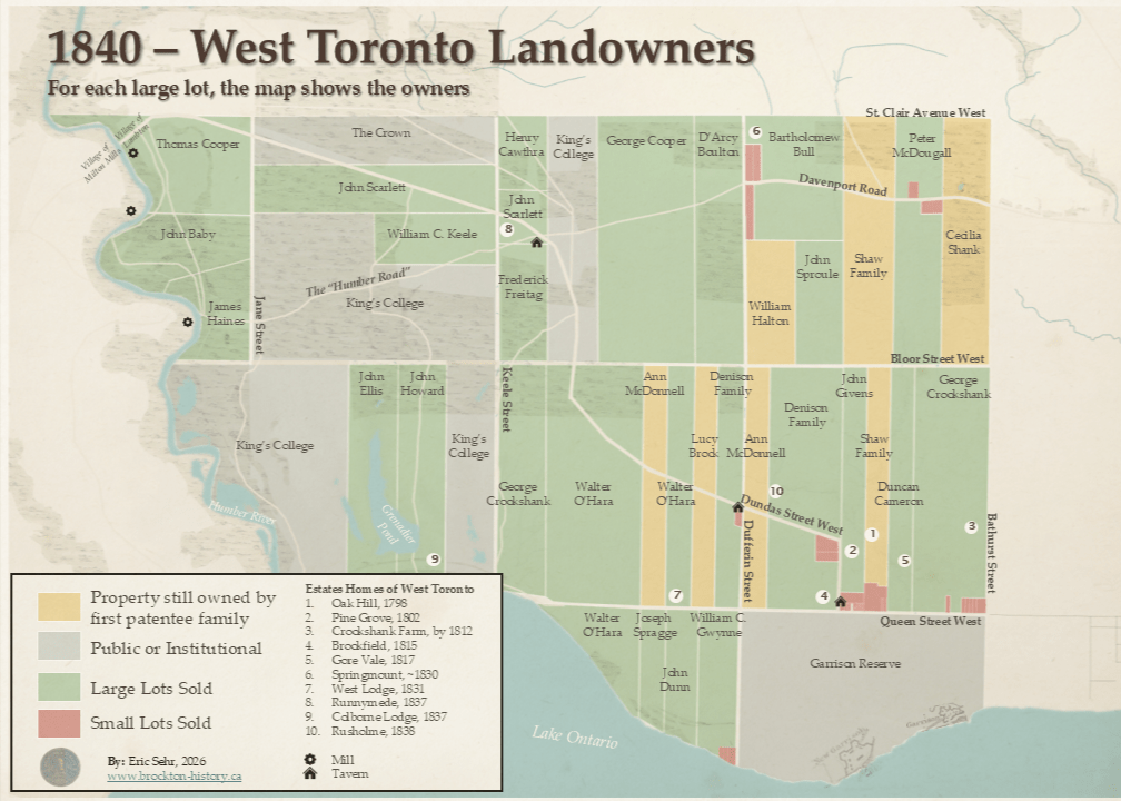
Land transactions picked up sharply through the 1830s and the local gentry firmly planted itself on the landscape and the Crown’s holdings were transferred to King’s College (now University of Toronto).6
Walter O’Hara, who arrived in 1826 with, by one account, a “respectable fortune to expend,” steadily expanded his landholding eventually buying most of David Shank’s old properties and establishing West Lodge on Queen Street.7 Absentee landholder Lucy Brock sold her property south of Queen Street, while Bartholomew Bull kept expanding his, and professionals John Ellis (a printer), John Howard (an architect), and William C. Keele (a lawyer) bought lands from King’s College for a steep discount.8
The ownership maps show only a small part of who actually occupied the land. Walter O’Hara’s diary illustrates how the land in west Toronto was generally worked by seasonal labourers, not by independent farmers. For example, in June 1837 O’Hara wrote in his diary:
June 8: Yesterday had two men only at work from the in[?] of rain who were engaged indoors this day, three? work. Hired John Reid on the 6th Tuesday for 8 dollars for month dismissed Patrick? on the 7th
Source: Landau, Daryl. The Founder of Roncesvalles and a Pioneer of Parkdale: Transcription of the Diary of Colonel Walter O’Hara, 2nd ed. E-book. Kobo, 2018.
June 9: men and cattle employed yesterday in drawing [dung] to garden.
June 21: Men (5) employed at job work clearing a road…
Transcribers note: “More complaints of lazy workers”
John Reid, Patrick, the men working on the gardens and roads won’t generally appear in the histories of the the west end, but these labourers and their small cottages would have been as big a part of the social and economic landscape as the estate homes and owners captured on the maps in this post.
Another change in the landscape, was the small subdivisions that started on Queen Street in the 1820s had by now expanded and spread to Davenport and Dundas. It was on a two-acre lot Dundas and Dufferin, first sold by the Denisons in November 1839, that Brockton Village would take root. We’ll take a closer look at this corner, and what grew from it, in the next post.
References
- Leo A. Johnson, Land Policy, Population Growth and Social Structure in the Home District, 1793-1851, Ontario History, vol. 63, no. 1 (March 1971), pp. 41-60; ↩︎
- Fisher, Sidney Thomson. The Merchant-Millers of the Humber Valley. Toronto: NC Press, 1985. pp. 68-69 ↩︎
- Ashe, Thomas. Memoirs and Confessions of Captain Ashe, Author of “The Spirit of the Book,” &c., &c., &c. Vol. 2. London: H. Colburn, 1815. Accessed July 3, 2026. Canadiana. ↩︎
- Upper Canada, House of Assembly, Appendix to Journal of the House of Assembly of Upper Canada (Toronto: W.L. MacKenzie, 1825), Library and Archives Canada. ↩︎
- Upper Canada, House of Assembly, Appendix to the Journal of the House of Assembly of Upper Canada … Third Session, Ninth Provincial Parliament, Sess. 1826-27 (York [Toronto]: W.L. MacKenzie, 1827), Library and Archives Canada. ↩︎
- The University of Toronto received between 223,000 and 226,000 acres across the province, which it sold to fund building projects on its campus. For an in-depth history of these lands see: University Lands Grabs: Indigenous Dispossession and the Universities of Toronto and Manitoba (PDF) ↩︎
- Geo. Mainer, “O’HARA, WALTER,” in Dictionary of Canadian Biography, vol. 10, University of Toronto/Université Laval, 2003–, accessed July 26, 2026, ↩︎
- King’s College sold its lands for £1.00 an acre, while the median price in the neighbourhood was over £18.00 an acre in the neighbourhood. ↩︎
 Brockton: A Lost Toronto Village
Leave a comment